June 9, Tuesday

 I took the B&B’s
recommendation to make my first stop, Glenveagh National Park. The landscape on this drive, and most of
Donegal, was distinctly different from Antrim and other parts of Ireland, being
less green, more brown, looking more like the Scottish Highlands. This makes sense, because the mountains here
are connected, geologically, to those of the Highlands (and the rest of the
Appalachian chain).
I took the B&B’s
recommendation to make my first stop, Glenveagh National Park. The landscape on this drive, and most of
Donegal, was distinctly different from Antrim and other parts of Ireland, being
less green, more brown, looking more like the Scottish Highlands. This makes sense, because the mountains here
are connected, geologically, to those of the Highlands (and the rest of the
Appalachian chain). My tripod and I started hiking to the top of a nearby hill, but realized I wouldn't have time and needed to abort the plan.
Glenveagh has a castle, though a fairly modern one, more a grand house, really, and nice gardens, situated on a long narrow lake between mountain ridges. It was privately owned, even by an American at one point, before eventually being taken over by the government in recent decades. It’s highly prized by the locals. I took some nice pix, walked through the gardens, which had absolutely huge orange poppies in bloom, and purple allium, then through the woods where some rare species only found at Glenveagh were in bloom (big red rhododendron bushes).

I left there and
continued to Mount Errigal, the highest peak in Donegal, and loads of cars were
there at the bottom, not sure why, but found it was folks hiking to the top of
it. I had no time for that this day. It’s distinctive.. looks like a volcano, but
made of metamorphic quartzite when sand from the sea margins was transformed to
sandstone then quartzite as Ireland, once partly in Europe, the other part in
America, came together 420 million years ago forming part of the Appalachian mountain
chain. At 2466 feet it is Donegal’s
highest and best known mountain. Down in
the glen nearby, was the picturesque town of Dun Lewey.
 From here, I pressed onwards
to Horn Head. On the way, I noticed a
dead sheep by the side of the road, and a dead deer on the other side, then
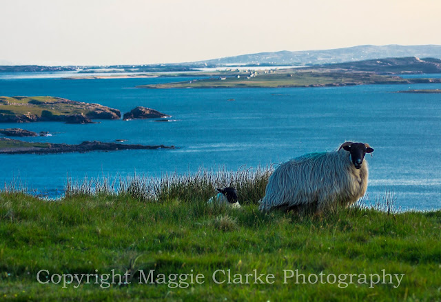
almost immediately live sheep roaming around in and near the road. Later I’d stop beside some of the sheep and
have bahing contests while getting shots and video of them, Mt. Errigal, gorse,
and other local wonders.
From here, I pressed onwards
to Horn Head. On the way, I noticed a
dead sheep by the side of the road, and a dead deer on the other side, then
almost immediately live sheep roaming around in and near the road. Later I’d stop beside some of the sheep and
have bahing contests while getting shots and video of them, Mt. Errigal, gorse,
and other local wonders. Conversation with sheep video
 I got into Dunfanaghy
(accent on second
I got into Dunfanaghy
(accent on secondsyllable, h silent), stopped at a museum, got some directions and headed up the single track (and I mean up) towards Horn Head, a peninsula jutting north from Donegal. This peninsula is quite high and surrounded by high cliffs. I successfully managed to get up there on the single track, but did meet several cars on the way down. I was amazed at the number of cars. I found places to pull out for the most part, but going up and coming back down there were times when another car and I had to squeeze slowly past one another. I could hear the hedge (and these were woody hedge) scraping against the side of the car, and we drivers were monitoring how close the mirrors were. We were close enough to reach out and touch one another, and could easily converse as we were navigating. Here's a shot I could take when the road widened enough, the hedge wasn't so close in, and there was a pullout.


Once I drove as far as I could, I hiked to the top of the highest point and explored the lookout, which the IRA left a calling card on, I shot a 360 video and surveyed the heatherlands of the Head, and headed back down to the car park to put on my boots and explore in other directions.
Horn Head video
There were lots of paths. I didn’t realize there would be that many, and the distances involved, as well as the dodginess of these paths. They would have been entirely impassable except that it hadn’t rained for so long. The soil was almost entirely peat / boggy when they weren’t rocky and steep. I spent quite a bit of time hiking and photographing, and in some cases, waiting for the sun to come out.
 I explored a number of different paths, but it wasn't too clear which ones would end in a dead end near a cliff or too steep slopes for comfort. I took some 360 degree videos and lots of
cliff shots.
I explored a number of different paths, but it wasn't too clear which ones would end in a dead end near a cliff or too steep slopes for comfort. I took some 360 degree videos and lots of
cliff shots.This was the first day of cloud, with rain coming sometime tomorrow. I hope to get the Slieve League, the biggest sea cliffs in Europe, in before that happens.
After Horn Head, on the
road to hopefully get some sunset pictures of “Bloody Foreland”, I took an
impromptu video as a herd of cows were being driven across the road by a couple
of teenage girls. I’m glad I had the
camera nearby; Crosby, Stills and Nash were singing Guinevere, adding to the
atmosphere.
Cows crossing the road video
I stopped for some dinner at a hotel along the coastal route towards the west, running into what seems to be a common situation when ordering any meal with beef in it… you can say you want medium rare and even say red side of pink, but they’ll cook it medium or worse. I thought the Mad Cow problem was done? I complained but didn’t want to waste the food or take the time for another meal to be cooked, so they gave me a nice chocolate dessert for free.
Back on the road, I saw a
sign for Bloody Foreland, took it, but it seemed at first to be going away from
the coast. I’ve seen references to
Bloody Foreland being a coastal rock prominence at the northwest corner of
Donegal but also a craggy mountain. Eventually, I ended up on another single
track, which went quite some distance along the shoreline, past lots of farms
and sheep, over a really dodgy looking single track wood plank bridge, past a
shore with big water-tossed, very well sorted, rounded rocks about 4” in
diameter.
Donegal coast of rounded stones
Eventually I got back to the main road (still an R – regional road, but 2 track anyway). These single tracks really get you out in the country to where the best scenery is, and force you to slow down and look around as you drive. After a short while, I found an actual overlook (something that’s rare in the British Isles, where several cars could park, with signage about the Bloody Foreland and history of the area, and why the Irish language still survives here), and I stayed there, trying to wait out the sun, which stubbornly stayed behind this singular cloud. At least the cloud was attractive!

I really wanted photos of the Bloody Foreland looking red rather than grey! While I waited I took some pix of sheep that were hanging out up there, and while I was changing lenses, looked up to see a stampeding herd of them followed by a border collie. See, there had been a farmer who came up in his jeep looking for the sheep. He brought is dog with him. I wasn’t really noticing or realizing the import of who he was or what he was about to do, as I saw him in his jeep. In finding the sheep, he set the dog loose. It would have been a good video, having taken place very close by. Never did get the shot I wanted of the Bloody Foreland either.
From there it was just a few more miles to Bunbeg House on the harbor. It seems like I’m destined to be losing time in the evenings and getting to bed late / not having enough time to write the journal. Tonight, just as I arrived, and had carefully parked in front, nine Germans arrived in a van, pulling up and stopping carelessly, jumping out and rushing to get to the buzzer before me. So I got to wait while the B&B sorted them out – they were even asking for one more room than they originally booked, causing more delay. I sat there for half hour, then 45 minutes totally ignored. There was even more delay because the wifi wouldn’t work in my room, so they got me set up in the living room. In doing this, they used one of my adapters, and in charging my international phone, I ended up leaving my adapter there. The Bunbeg House was a bit more rudimentary than the last two nights and cost more as well. I’ll remember this.
Donegal coast of rounded stones
Eventually I got back to the main road (still an R – regional road, but 2 track anyway). These single tracks really get you out in the country to where the best scenery is, and force you to slow down and look around as you drive. After a short while, I found an actual overlook (something that’s rare in the British Isles, where several cars could park, with signage about the Bloody Foreland and history of the area, and why the Irish language still survives here), and I stayed there, trying to wait out the sun, which stubbornly stayed behind this singular cloud. At least the cloud was attractive!

I really wanted photos of the Bloody Foreland looking red rather than grey! While I waited I took some pix of sheep that were hanging out up there, and while I was changing lenses, looked up to see a stampeding herd of them followed by a border collie. See, there had been a farmer who came up in his jeep looking for the sheep. He brought is dog with him. I wasn’t really noticing or realizing the import of who he was or what he was about to do, as I saw him in his jeep. In finding the sheep, he set the dog loose. It would have been a good video, having taken place very close by. Never did get the shot I wanted of the Bloody Foreland either.

From there it was just a few more miles to Bunbeg House on the harbor. It seems like I’m destined to be losing time in the evenings and getting to bed late / not having enough time to write the journal. Tonight, just as I arrived, and had carefully parked in front, nine Germans arrived in a van, pulling up and stopping carelessly, jumping out and rushing to get to the buzzer before me. So I got to wait while the B&B sorted them out – they were even asking for one more room than they originally booked, causing more delay. I sat there for half hour, then 45 minutes totally ignored. There was even more delay because the wifi wouldn’t work in my room, so they got me set up in the living room. In doing this, they used one of my adapters, and in charging my international phone, I ended up leaving my adapter there. The Bunbeg House was a bit more rudimentary than the last two nights and cost more as well. I’ll remember this.
No comments:
Post a Comment