Monday, July 29, 2013

June 14 - Killarney and Dingle

June 14, Friday  Killarney and Dingle

Today was looking like our weather luck was going to run out.  It was raining at breakfast (which was not the best on this trip) and also when we got to Muckross House and gardens, the Torc waterfall (always a good subject for rainy days), and the Ross castle.  We spent an hour and a half in the Muckross grand house on tour, dozens of rooms, an intricate system of pull cords to summon specific servants for specific masters and mistresses, and yet no electricity until I think they said the 1960s.  Looking at the clouds through the windows... impressive!

We spent more time in the house than at the waterfalls and Ross castle combined.. less than we might have since it was pouring and windy at times.  At the castle, we just took a glance at it and returned to the car.


But I have taken waterfall pictures in the pouring windy rain before (south Wales), so spent some time and the parts of me not protected by my Oregon rain jacket got a bit soggy. But I did get some nice shots.

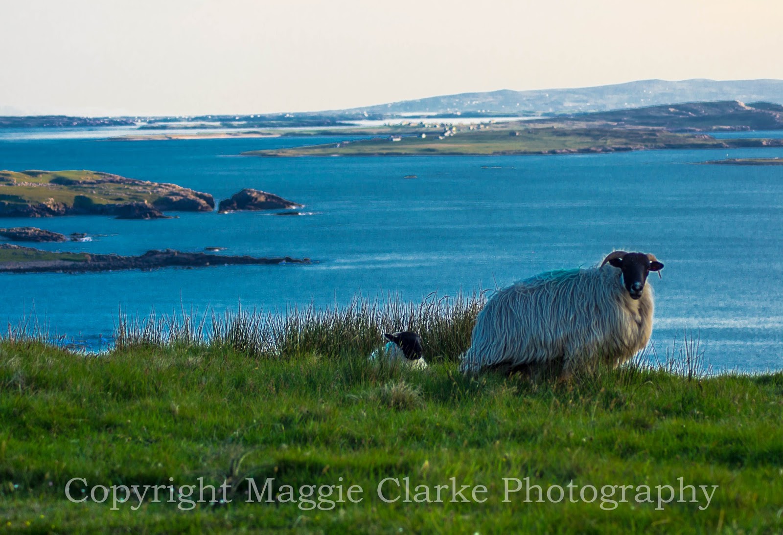
Undeterred, we headed out to the Dingle peninsula, the one that everybody, bar none, had recommended highest, hoping that the forecast for clearing later in the afternoon might come to pass.  On the CD player today was Carly Simon, America, and Billy J. Kramer’s new CD.  It was pouring much of the way out, and we decided to have lunch at Dingle town and wait a bit.  We strolled some of the woolens stores, the harbor, and noticed the boat rides to look for Fungi, the dolphin, which has become a bit of a tourist attraction.  Pleased to say, the waiting paid off.  After a little doze in the car, by around 4:30 or 5 it was starting to clear as the weather forecasters had predicted, and we took a narrow road along the cliffs to the lowest loop of the Dingle peninsula, called Slea Head).  This loop had some of the most dramatic scenery I’d seen in days. The view of the islands and nearby cliffs was great. 


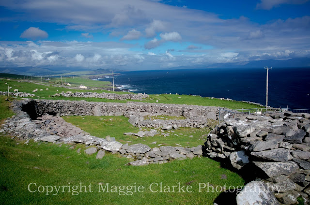
This area has a lot of very old archeological sites, so on our way down the coast, we stopped at a few of them, one a fortification 2500 years old, right near some of the “most spectacular cliffs in Ireland” (so the sign said, and I’m thinking yes).


A few miles down the road were other sites 2000 years old, ring forts and beehive huts, where they skillfully used flat stones with no mortar to create watertight homes in the shape of beehives.


Did I say the road was narrow?  Couldn't find a place to pull out so took this one through the windscreen. Thankfully I didn't meet any cars in the narrowest bits that had no pullouts.  I think that dotted yellow line was to indicate a place for two cars to pass since there was a few inches extra on that side....


At the bottom end of the Dingle peninsula, Slea Head, is where they filmed Ryan's Daughter.  I got lots of great photos of all this, and a 360 degree video.

Slea Head, Dingle video

On the way back towards Dingle town, we saw a pottery store that was still open, just before 7, and headed in.  Louis Mulcahy’s two story shop of wonderful wares proved irresistible.  I bought a few pieces and had them sent home.  BTW, Mulcahy is pronounced with a short “a”, like cat, not a long “a”, and finding out later, he has quite a good reputation in the region.

Dingle hills video

Then continued heading back to Dingle.   All the little road signs were only in Gaelic.  The map wasn't totally clear about which one of the twists and turns would lead back to Dingle, so at just the right time, I asked a fellow for directions, and he pointed (mumbling the signs clearly said Dingle.. of course in Gaelic, which is An Daingean).   It rained now and then, with some sunny windy bits, but once back at Dingle, got some last shots of the harbor, and found ourselves a nice dinner at the Dingle Bay Hotel's restaurant, a really cool place with rock, wood, and brick interior, and enjoyed some live music there -
a bassist/vocalist and guitarist/harmonica/vocalist.  I got a dish of pasta with cheese, veg and tomato sauce – looking lovely but Very spicy.  The hostess fetched me some milk, on the house.  It turned out to be a quick antidote to spicy dishes!  Who knew?


It rained all the way back to Killarney; Lorraine did the driving.  One of our hostesses at the Woodlawn House gave us some more great directions for tomorrow (she’d made good ones for this day).  Rain is predicted again.  Crossing fingers. 

Saturday, July 27, 2013

June 13 - Blarney to Killarney


June 13, Thursday  Blarney to Killarney via Kerry and Beara Peninsula

We lucked out big time today.  The day started with some bits of sun coming through and no rain!  The prediction was not good.  Our hostess repeated her recommendations, this time, with hand drawn maps to get us to the Blarney Castle and gardens and lawns (quite extensive, including a poison garden.. very interesting).  Thanks to Lorraine’s suggestion, we both got in for the senior rate, even though I was to turn 60 in July.  The castle itself is quite imposing, since it sits on a rock outcropping that is 8 meters high.  We watched as people climbed to the top, bent over backwards, literally, to kiss the Blarney stone to get the gift of gab.  We passed on it for various reasons.  I’d heard that the locals put nasties on it. If you want to kiss the stone, you climb to the top of the castle, stand in a line, get to the spot, lean over backwards, sort of dangling out a window ledge.  We have better things to do today.


Instead we went through the poison garden, and I found myself surprised at some of the plants in there.


From there we followed the instructions out towards Bantry Bay, and Glengariff on the Beara peninsula.   Today on the CD player, were Eagles, Billy J. Kramer’s new one, Herman’s Hermits, Zombies live, and Zombies Oracle and Odyssey).   In the British Isles, they don’t normally give instructions using road numbers, like N72 or R585, but rather go to the roundabout, take a right, then cross the next road, go around to the right, hang a left at the petrol station, left at the T, then it’s a few minutes down the road. Now and then you get an assemblage of signs like this.. not exactly easy to be reading at 30mph or more...

The road towards the Ring of Beara was a tight 2 lane, where the width of trucks is exactly the width of a lane.  Much of it was hemmed in by hedges as much as two stories high, immediately at the outer edges of the driving lanes. 

We spent some time in Glengariff, right at the entry point to the Beara peninsula.  There were lots of woolen shops, so I got a scarf and socks, and we grabbed some lunch (Irish Stew, with lots of root veg) just before the tour buses got there.  There was a bike ride to benefit Autism going on as well.  It was at a picturesque spot on the top of the bay.  From there, we drove down to Castletown Bere, more of a working marine town, walked around a bit there, then crossed to the other side of the peninsula, where the next bay over (Kenmare River) was very blue and very pretty. This shot shows Kerry peninsula from the east.


We went north along the west edge of the Beara until we saw a sign for a stone circle.  Thought that might be nice so took the even narrower road inland into the Caba mountains.. quite imposing.  The road, after another turn, was a true single track through tunnels in the trees, some made of purple flowering rhododendron, which grows like weeds there.  We were losing hope after many kilometers of driving and a number of turns onto narrower and narrower roads.  Finally we got to what looked like a dead end at a farmhouse, and there was the Shronebirran stone circle right nearby.  There were two sheep sitting inside.. very fitting.. took pictures.  The mountains surrounded us, most very rocky, showing the internal structures quite clearly.  This was a good diversion.


Got back out to the Ring of Beara and up to Kenmare, another picturesque town at the top of the Ring of Kerry, but just passed through, though it would have been nice to stop.


The “Ring of Kerry” is the most popular of the peninsulas, just to the west of the Beara peninsula, and we only had time to do part of that.  I was told over and over how crowded the Ring of Kerry would be, which direction to do it because of all the buses that there would be.  Clearly the cyclists like it.


So we figured we could go partway down the east side, down to Sneem, a river town, and then head back towards Killarney through the highlands in the middle of the peninsula.  Sneem was a very quaint town with a music store so we went in.  They had lots of the traditional Irish drums in there.  The bodhran has the shape of a tambourine, but no rattles; you play it with a short stick with two smooth carved ends).  I decided to get one.  I’d earlier bought an Irish tin whistle.  We crossed the river, which had amazing formations in it, metamorphic rocks, in beds upended (lots of photo opps here!).   This is the picturesque Sneem river.


From Sneem we went inland and up, up, up, to and over mountains, traveling in mountain valleys and occasionally over some “gaps”.  The landscape was quite extensive.  It looked like parts of the Scottish highlands.  From there we went over the Moll’s gap.

Kerry video


Leaving Kerry, we headed down into Killarney National Park, extremely picturesque with a string of lakes, near a string of mountains, a castle, a mansion, gardens and a waterfall.  There were lots of sheep and cyclists in the road in the area.  Wishing I could be one of those on a bike.

Killarney National Park drive video

Got into the Woodlawn B&B, picked up the package that the Bunbeg house sent (my British Isles AC converter), then set out on foot for the congested Killarney town center, 10 minutes away.  It was going on 9pm at this point and we were starving again.  Made the mistake of thinking too long about which restaurant to choose, and started finding one after another had just closed.  Eventually we found one that was still serving food.  Once again the portion size was huge.  I had lamb chops.  I couldn’t even begin to touch the three scoops of potatoes.  No room for dessert.  Back at the B&B, since internet was going in and out (they blamed a town-wide outage.. I wasn’t so sure), but did manage to Skype Mom and write notes for this blog.

Since we got into town late, we will plan to see the castle, gardens, and waterfalls tomorrow along with the Dingle peninsula.  Hope the weather is better than the forecast.

Friday, July 26, 2013

June 12 - Dublin to Blarney

June 12, Wednesday Dublin to Blarney

I did get that elusive early start, gravitating to the internet equipped laptop in the breakfast room while I waited for my Irish breakfast.  Yay!  Why I keep tasting the blood pudding is beyond me though….  I’ll leave that to the Irish, Scots, Brits, etc.   The bus took only an hour this time, I met Lorraine, got her signed up as a driver on my car, and headed out.  It rained on and off as we made our way down various motorways M1, M50, M7, M9, N7, N10, with an R road thrown in there while we went way off course, on purpose, but pretty, to get some diesel. 

We aimed to stop in Kilkenny, a medieval town.  After I parked and was about to pay for a parking chit, someone gave us one for 50 minutes (This amount of time was perfect).  The Irish ARE helpful!   We walked around Kilkenny, a town with a castle, a cathedral and some nice old walls, narrow streets, and grabbed some soup al fresco (since it stopped raining for a while).  I noticed that the British Isles version of minestrone or vegetable soup is not tomato-based, but root vegetable based, and is yellow/mustard colored, not red.  Carrots, potatoes, onion, turnips and parsnips are big.  I realize that has to do with climate… the cooler, cloudier climate isn’t best for above ground crops like leafy veg, tomato, corn, etc. 

From there we proceeded to Waterton (where the crystal is made), and on to Cork.  We’d seen a sign for a craft shop, and went looking for it… over 10 km later, had found nothing.  That turned out to be a costly mistake in terms of time, what with stores and attractions closing so early.  We got to Cork just before rush hour, and got stuck in the city for about an hour, our second costly mistake of the day.  I’d never seen a city time lights for 5 seconds!  The City is laid out with lots of coastal inlets, shorelines, one way streets, bridges and such, so that increased traffic levels and made it harder to get around.  The quick lights would allow maybe 3 cars get through and then we stop again.  On a sunny day with time available, Cork might have been a bit nicer.  I realized that stricter time planning would have probably kept us on better track, and we did that much better for the rest of the trip.

It took us some extra time to find the Pine Forest B&B just outside Blarney, since Google maps mislocated it.  It was the only one I’d not been able to find using Street View before leaving home.   We were looking for it from a different road maybe a mile away, and driving a little slowly, I pulled off into the entrance of a housing development, and the car behind me also pulled in.  We noticed she was waving at us, and then we realized she wanted to help us find our way.   She gave us extremely accurate directions, amazed she knew our B&B.  I’d heard the Irish were friendly, and this underscores that.  I’m sure we would have been searching for a long time.  We were starving by this time.  The B&B was one of the nice ones in a large private home on extensive grounds with lovely gardens.  Our hostess was very nice and welcoming.  All these mistakes cost us the opportunity to see Blarney Castle grounds that evening.  I’d thought for sure we could walk around the outside castle grounds late (since sun doesn’t set till 10), but noooo. 


She sent us a few miles away to an absolutely wonderful pub (Blair House) for some great food.  I had a special – pork with apple crisp on top, assorted veg (which I’m lately finding is carrot, broccoli and turnip), and for the two of us to share, a plate of three gigantic new potatoes!  There was another plate with lots of root vegetables!   Got back to the B&B, had a nice time talking with a few of the other guests, one of whom, was a young woman from Georgia who had just arrived in Ireland that morning.  It was her first flight anywhere, and she had been delayed, majorly, jet lagged, etc. but was holding up really well.  So we talked some more about routes for the next couple of days, our hostess giving us suggestions about routes for upcoming days headed towards Kerry and Dingle peninsulas, and Killarney National Park, and even Cliffs of Moher, with tips on how to plan including the weather (i.e. if you get to this place and can’t see the far shore, abort this part of the route and go this other way, and do this other thing).  This proved to be invaluable advice, and we didn’t have the kinds of costly mistakes as before.  We ordered our specific breakfast for the morning (this B&B offers more than the usual Irish, with salmon and waffles as two other options).  We’re still not sure what we are going to do in the morning, but weather will dictate to some extent.

June 11 - Largymore to Dublin

June 11, Tuesday
The day started grey and raining.  My hostess, Ethna Diver, said this is more typical weather in Ireland.  I was really lucky with the streak of nice days.  Since I was tiring of the Full Irish, I had an omelette for a change, with an offering of white and black pudding on the side.  OK, for the Americans reading this, white pudding is a small hockey puck looking thing which is made of the parts of animals not normally eaten, like ears, knuckles, and feet and such, while black pudding is the same except it’s very dark brown, and also including animal blood.  She said it’s an “acquired taste”.  I found the white isn’t bad in small quantities.  Her hot chocolate was Great – milk with actual chocolate melted into it.  I remember having had it that way in Gronigen, Netherlands once, where you are given hot milk and a stick with chocolate at the end to dip…  but I digress.  I’d forgotten to get cash to pay since she was not set up to take credit cards, so we drove caravan style to Killibegs, a nearby seafaring town to find an ATM.  It was on my way towards Dublin and she needed to do errands in town anyway.  This was one of those places and hostesses I found hard to leave. 

Then I was off, in the rain, towards Donegal Town, then Sligo.  I’d originally planned to stay above a pub in Donegal Town (which would have been noisier) but, at Paddy Byrne’s suggestion, had changed to Largymore thinking I’d be doing the sunset boat cruise with him.  You see how things can change all over the place.  After Donegal Town, heading towards Sligo, these were some of the widest highways I’d been on in days.  I knew I had to make time in order to maximize my time in Dublin that afternoon/ evening and I was driving not only from the west coast to the east, but also south a ways. 

Then I saw the sign for Glencar waterfalls.  I had to go.  There was no indication how far I’d need to drive.


It turned out to be a narrow road for 10 km each way, but once I got there, I got some great shots.  There was the Glencar lake as well adjacent to the parking lot; sheep in the foreground, hill behind the lake.


Following my nose, I found my way back on track, though I think by a different route, and took a quick tour of Sligo town, but didn’t stop, deciding to stop for a quick, portable lunch (ice cream on a stick) in Carrick on Shannon, a picturesque town on the Shannon river, doing a half hour’s walking tour (suggested by Ethna). 

From there it was on to Dublin airport to drop the car overnight.  Everybody said not to drive into Dublin and instead take a bus from the airport.  Unfortunately, all my self-imposed delays had me arriving at the very heavily traveled M50 Dublin ring road and the airport at early rush hour.  It was a bit hairy, but the occasional NYC and other city driving I’ve done was plenty to prepare me.  Navigating to the Europcar outer lot, dropping the car, finding the bus to the terminal, another bus to town (the 747, airport bus, aptly named), waiting, taking it all the way to the end, and walking, with my bags, took almost 2 hours.  I sure hope it’s faster in the morning, but expect to run into rush hour traffic again going back to the airport to meet Lorraine. 

The Gate Lodge in Dublin was basic lodging, similar to the row house I stayed in in Belfast.  The Internet didn’t work in the room.  Seems I lurch from lovely to basic and back again this tour.  It will be interesting to compare the listed ratings to my ratings.  I’m glad they advised me to buy a Rambler ticket for the day since for an extra 30 cents above the cost of one way from the airport, I could get unlimited travel on buses.  After dropping the bags at the Gate Lodge, I took the bus (near the Gate of Phoenix park, huge, probably wonderful, but I had no time to see it) to Trinity College, downtown.  The location of the Book of Kells (or as some snarkily refer to it, the Page of Kells, since only one page is shown to the public) is there, but I really didn’t have time or interest to stand in line.  It was too late by the time I got there anyway and it was still raining.  Even the campus didn’t seem that extraordinary, having seen and lived in plenty of Eastern US Ivy league college campuses.  Stores and pretty much everything shuts by 6pm.  So I walked the Grafton pedestrian shopping mall, with many others, but only the most touristy shops were still open.


I went into St. Stephens’ Green, which I expected to be like other town Greens I’d been to in New England, but no.  This was more akin to Central Park, a heavily landscaped place with curved walkways, occasional plantings of flowers, watercourses and bridges, etc.  I would have stayed to enjoy it, but it was still raining and getting chilly.  I continued west towards the medieval part of town, and then north into the “Temple Bar” area.  This place was hopping with young folks cruising the pubs.  I continued walking around the south of River Liffey downtown.

 All during this walk, I’d been in touch with a colleague who I met frequently at the annual solid waste conference in Philadelphia and who is a professor at the Dublin City University, so with quite a few texts, we met in Dublin back on the Grafton pedestrian mall.  She found an old, famous place for us to eat, and we caught up.  It was nice to see her.  She had also taken a solo trip in the southern US, so we had plenty to talk about.  I remembered, too late, that in ordering dinner don’t order anything beef in the British Isles.   Same as in Canada.. fear of mad cow disease, so they overcook.   She’d parked near St. Stephen’s Green, so we walked the perimeter of the park, noticing all the barricades going up around a big hotel she said that dignitaries often stayed at, and the Obamas were planning to stay at in a few days, and she gave me a ride back to the Lodge, as it was on her way home anyway.  I realized I must get out much earlier tomorrow morning since I need to pick up Lorraine at the airport.  If the bus takes 2 hours again, our start to get to Blarney in the south will be quite delayed.

Thursday, July 25, 2013

June 10 - Bunbeg to Largymore

June 10, 2013 Weds.
Surprisingly, the day started with clear blue skies again but windy.  I thought the advance clouds of the cold front had already arrived.  It was important to get the weather forecast straight today because I had planned to take a boat ride under the Slieve League at sunset and to drive up towards the top and hike there.  All of that required good conditions.  In retrospect, I should have gotten up a half hour earlier and not stopped at the B&B or the boat launch before going to the top.  It was hard to predict. 

This morning the staff were doing their best to be attentive, I suppose to make up for what happened last night.  I got set up in the basement living room while waiting for breakfast to be cooked, so that I could use my laptop (close to the wifi source).  I managed to get out at 9:45 (the earliest yet), and went straight towards the south Donegal coast, which means lots of zigging and sagging through the mountains.  But distances are short and it’s scenic.  But the speed limit signs are crazy.  Frequently you see 100 km dropping to 50 km outside a town, but today there was a 100 km sign as I was going over a straight flat bridge (fair enough), but then the road immediately narrowed, and started winding through the mountains.  There’s no way anyone could or should be going that speed under such conditions.

I stopped in Ardara to look for woolens.  I wasn’t planning to spend much time, but, as expeditiously as I could, cased four shops (this is a town known for Donegal woolens), got a couple of mohair scarves, a calendar for next year, and in the last shop found a pair of dark green herringbone trousers that fit except for the length.  At this place, they not only do adjustments for free, but will weave and tailor you a whole garment out of the pattern you choose for the same price and mail it to you.  I saw the weaver plying the loom in the back room.  The tailor was excellent; she made notes not just about taking in but also adding material under the arm… fairly complex tailoring.  I ordered a waist coat (vest) to match the trousers.  Who knew I was going to do this today?  Clearly, it was a good place, as there was a tour bus outside when I arrived (and when I left..same one).


Once at the south Donegal coast road, heading west in the direction of the cliffs, I saw my B&B, so thought I’d just go in and drop my bags, figuring it wouldn’t take that long.  Two scones, butter and jam (lunch), some chitchat, discussion about routes later, and I was off, taking a nice diversion down the one lane coast road.  This coast road was so spectacular because it was both coastal and mountainous at the same time.  I met a few cars coming the other way full speed, but at this point,  I’d learned what to do.. look for where to duck, pull over, wait.  It was easy to see cars coming from some distance on this road.  I took some shots here and there of the farms built on the hillsides of the rugged coastline. 


.  
The sun was still out, as I raced along the river, above, to see Paddy Byrne at the Teelin boat ramp.  Unfortunately, he wasn’t there at 2:45.  His normal departure schedule was every two hours starting at 10 am, so at this point, he was out until 4.  What to do?  Clearly I wasn’t going to hang there till then, and unfortunately, the clouds had just rolled in, getting windier.  So I went to the TeeLin cafĂ©/tourist cottage at the bottom of the climb up to the Slieve League parking lots, looked around, introduced myself to Paddy Clarke (we’d corresponded before), and headed up the mountain.  I’d been rather nervous about the prospect of driving this road, since it was barely 2 track up to the first parking lot and then Google Map’s Street View didn’t go any further.  That told me that they didn’t trust their vehicle to go up the narrow road with sheer cliffs to the second parking lot.  So, I looked it up on Google Earth, and on satellite image the road was clearly narrower, more winding, and closer to the cliffs.  Paddy said they’d widened the road a few years ago, and I’d gotten more opinion from one of the other tourists on the Derry walking tour a few days before that he’d done it.  So I figured I’d go for it, having been on a lot of single tracks in the last few days, but also knowing I probably could not turn back once committed to drive past the first parking lot.  Once I opened the sheep gate to the rest of the road, someone was nice enough to close it after me.  Thankfully, it turned out that this road was not a true single track, and mostly the cliffs were not sheer off the side of the road.   I met only a few cars going up, but there was no problem navigating around them. 

At the top parking lot, it was overcast and the winds were gale force so photography was going to be suboptimal and a challenge.  The guy in the Irish ice cream truck (a little yellow truck in the video of Slieve League Descent, below) was nice to chat with.  I’d described my dilemma about whether to go on the boat trip, how I’d contacted Paddy Byrne, the uncertainty about the weather, etc, whereby he told me to go closer to the edge of the cliff where I could see Paddy Byrne in his boat down in the water.  It was almost like a speck in the ocean, from almost 2,000 feet up but I could see the boat pitching about once a second, and realized I was lucky not to be in that boat.  The wind was so fierce, even holding my camera on my tripod on solid ground, there was some vibration.  Since everybody else was doing it, I headed up the mountain.  There were a couple dozen folks on their way up or down.  I don’t know how far I climbed in altitude, but hundreds of feet at least.  One German family recognized me from yesterday .. “didn’t we see you at Horn Head?”   There were lots of Germans, French, Italians, and Americans around.   Using the tripod, I took some shots of myself with Slieve League cliffs in the background, then went up higher, did a panorama. Here are a few of the many photos I shot up there. Isn't it beautiful? Next time, I'll allow more time for hiking. There is a part of the five hour hike along the top of the long mountain ridge that is called One Man's Pass, which is so narrow, only one person can walk on it, and there is a very steep drop off on both sides.


Because I didn’t want to be descending from the mountain in the rain, went back down as soon as I could. My car is parked on the edge at the bottom of the path, round the bend to the left in this photo.

I did take the time to enjoy some of the nice man’s Irish ice cream, and the “chocolate chip” was absolutely devine!  It was chocolate with chocolate chips with a hint of mint. 

I then drove down the mountain, but first set up my smaller, “concert” camera above the steering wheel to shoot a dashcam.  The ice cream guy said he knew of YouTube videos going up the mountain, but not coming down.  It’s actually more dramatic going down.  You can see how far you can fall!  As it turned out the rain started during my descent as seen on the windshield, though I wasn’t really focusing on that.  There were sheep, hikers, and the prospect of meeting cars head on to focus on.


After coming down Slieve League, since there were still a few hours before sunset, I headed to GlenColmCille, a tiny village near the southwest coast of Donegal.  It was raining now, as I went through the Folk museum, which showed how the area went from the middle ages to the modern era in a few short decades, after about 1960, thanks to the local priest.  It was stunning to realize how much of Ireland lacked modern utilities like electricity and hot and cold running water until just a few decades ago.  On my way across and back from GlenColmCille (pronounced Glen Colm Kill), I noticed that there were people in the fields who had driven there, and it looked to me as if they were mining the peat.  The earth was clearly partially dug and dislodged by farm equipment.  I’d heard that peat used to be burned for heat.  It would make sense that there would be peat in this area, being a long valley between the Slieve League mountains and the uplands to the north.  I’m sure this also was a tradition (peat mining) in this area.  But not a great thing to realize that the peat, wonderfully rich soil for growing things, is mined for purpose of burning it, especially since burning peat adds to the CO2 in the atmosphere.  Getting back towards the area of my B&B in Largymore near Kilcar it was hard to find a place to eat!  I’d been warned about this by my B&B hostess.  Who knew?  You can’t eat out on Sunday night.  Even pubs were closed.  Eventually, I found a really nice meal of “3 fowl” at Kitty Kelly’s (named after an old warlord).  On the way in, prominent on the walls, were framed photos of Matthew Broderick and Sarah Jessica Parker.  They told me that this is a favorite haunt of theirs and they have a place nearby, Kilcar area.  Interesting.  And since one of my friends lives a few doors down from them below Greenwich Village, I know two places they live.  Tonight’s B&B is new, comfortable, well appointed, with a nice hostess.  Since she had been full up the night before, and this night I was her only guest, she gave me quite a bit of attention.  The house also has a fantastic view of the coast from up high.  On a clear day, one can see across the Donegal bay, where I’ll drive tomorrow (to Sligo) on my way back to Dublin.


Monday, July 22, 2013

June 9 -- Letterkenny to Bunbeg

June 9, Tuesday

After another amazing breakfast at an equally nice place as the night before, this time, in Letterkenny, in County Donegal, I was back in Euro country, so went back towards Letterkenny to get some of those at the little foods store attached to the petrol station.  Got some diesel, which was cheaper in Ireland, as had been suggested, and I started buying some provisions for lunch on the go.  I noticed they sold coal there as well!  This long day was to be spent entirely in rural areas, partly in the mountains and partly along the shoreline, and didn’t want to have to concern myself with finding food.


I took the B&B’s recommendation to make my first stop, Glenveagh National Park.  The landscape on this drive, and most of Donegal, was distinctly different from Antrim and other parts of Ireland, being less green, more brown, looking more like the Scottish Highlands.  This makes sense, because the mountains here are connected, geologically, to those of the Highlands (and the rest of the Appalachian chain).


 My tripod and I started hiking to the top of a nearby hill, but realized I wouldn't have time and needed to abort the plan.


Glenveagh has a castle, though a fairly modern one, more a grand house, really, and nice gardens, situated on a long narrow lake between mountain ridges.  It was privately owned, even by an American at one point, before eventually being taken over by the government in recent decades.  It’s highly prized by the locals.  I took some nice pix, walked through the gardens, which had absolutely huge orange poppies in bloom, and purple allium, then through the woods where some rare species only found at Glenveagh were in bloom (big red rhododendron bushes). 


I left there and continued to Mount Errigal, the highest peak in Donegal, and loads of cars were there at the bottom, not sure why, but found it was folks hiking to the top of it.  I had no time for that this day.  It’s distinctive.. looks like a volcano, but made of metamorphic quartzite when sand from the sea margins was transformed to sandstone then quartzite as Ireland, once partly in Europe, the other part in America, came together 420 million years ago forming part of the Appalachian mountain chain.   At 2466 feet it is Donegal’s highest and best known mountain.  Down in the glen nearby, was the picturesque town of Dun Lewey. 

From here, I pressed onwards to Horn Head.  On the way, I noticed a dead sheep by the side of the road, and a dead deer on the other side, then almost immediately live sheep roaming around in and near the road.  Later I’d stop beside some of the sheep and have bahing contests while getting shots and video of them, Mt. Errigal, gorse, and other local wonders. 

Conversation with sheep video

I got into Dunfanaghy (accent on second
syllable, h silent), stopped at a museum, got some directions and headed up the single track (and I mean up) towards Horn Head, a peninsula jutting north from Donegal.  This peninsula is quite high and surrounded by high cliffs.  I successfully managed to get up there on the single track, but did meet several cars on the way down.  I was amazed at the number of cars.  I found places to pull out for the most part, but going up and coming back down there were times when another car and I had to squeeze slowly past one another.  I could hear the hedge (and these were woody hedge) scraping against the side of the car, and we drivers were monitoring how close the mirrors were.  We were close enough to reach out and touch one another, and could easily converse as we were navigating.  Here's a shot I could take when the road widened enough, the hedge wasn't so close in, and there was a pullout.


Once I drove as far as I could, I hiked to the top of the highest point and explored the lookout, which the IRA left a calling card on, I shot a 360 video and surveyed the heatherlands of the Head, and headed back down to the car park to put on my boots and explore in other directions.

Horn Head video

There were lots of paths.  I didn’t realize there would be that many, and the distances involved, as well as the dodginess of these paths.  They would have been entirely impassable except that it hadn’t rained for so long.  The soil was almost entirely peat / boggy when they weren’t rocky and steep.  I spent quite a bit of time hiking and photographing, and in some cases, waiting for the sun to come out.

I explored a number of different paths, but it wasn't too clear which ones would end in a dead end near a cliff or too steep slopes for comfort.  I took some 360 degree videos and lots of cliff shots.
This was the first day of cloud, with rain coming sometime tomorrow.  I hope to get the Slieve League, the biggest sea cliffs in Europe, in before that happens. 

After Horn Head, on the road to hopefully get some sunset pictures of “Bloody Foreland”, I took an impromptu video as a herd of cows were being driven across the road by a couple of teenage girls.  I’m glad I had the camera nearby; Crosby, Stills and Nash were singing Guinevere, adding to the atmosphere.

Cows crossing the road video

I stopped for some dinner at a hotel along the coastal route towards the west, running into what seems to be a common situation when ordering any meal with beef in it…  you can say you want medium rare and even say red side of pink, but they’ll cook it medium or worse.  I thought the Mad Cow problem was done?  I complained but didn’t want to waste the food or take the time for another meal to be cooked, so they gave me a nice chocolate dessert for free. 

Back on the road, I saw a sign for Bloody Foreland, took it, but it seemed at first to be going away from the coast.  I’ve seen references to Bloody Foreland being a coastal rock prominence at the northwest corner of Donegal but also a craggy mountain.  Eventually, I ended up on another single track, which went quite some distance along the shoreline, past lots of farms and sheep, over a really dodgy looking single track wood plank bridge, past a shore with big water-tossed, very well sorted, rounded rocks about 4” in diameter.

Donegal coast of rounded stones

Eventually I got back to the main road (still an R – regional road, but 2 track anyway).  These single tracks really get you out in the country to where the best scenery is, and force you to slow down and look around as you drive.  After a short while, I found an actual overlook (something that’s rare in the British Isles, where several cars could park, with signage about the Bloody Foreland and history of the area, and why the Irish language still survives here), and I stayed there, trying to wait out the sun, which stubbornly stayed behind this singular cloud.  At least the cloud was attractive!


I really wanted photos of the Bloody Foreland looking red rather than grey!  While I waited I took some pix of sheep that were hanging out up there, and while I was changing lenses, looked up to see a stampeding herd of them followed by a border collie.  See, there had been a farmer who came up in his jeep looking for the sheep.  He brought is dog with him.  I wasn’t really noticing or realizing the import of who he was or what he was about to do, as I saw him in his jeep.  In finding the sheep, he set the dog loose.  It would have been a good video, having taken place very close by.  Never did get the shot I wanted of the Bloody Foreland either.


From there it was just a few more miles to Bunbeg House on the harbor.  It seems like I’m destined to be losing time in the evenings and getting to bed late / not having enough time to write the journal.  Tonight, just as I arrived, and had carefully parked in front, nine Germans arrived in a van, pulling up and stopping carelessly, jumping out and rushing to get to the buzzer before me.  So I got to wait while the B&B sorted them out – they were even asking for one more room than they originally booked, causing more delay.  I sat there for half hour, then 45 minutes totally ignored.  There was even more delay because the wifi wouldn’t work in my room, so they got me set up in the living room.  In doing this, they used one of my adapters, and in charging my international phone, I ended up leaving my adapter there.  The Bunbeg House was a bit more rudimentary than the last two nights and cost more as well.  I’ll remember this.