Saturday, July 6, 2013

June 8 - Ballymoney to Letterkenny

In the morning breakfast was a wonderful panoply of offerings.. too many to take advantage of.  I had filled out a breakfast order sheet the night before, including when I wanted it.  Many things were local and organic.  There were the usual cereals and yogurts out on the side table as the initial offering.  I ordered a bowl of fresh fruit, veggie sausages, eggs, tomatoes, wonderful buttery mushrooms, potato pancake, baked beans and hot chockie.  Too much.. couldn’t finish.  But it kept me going till late afternoon.  The springer spaniel was happy for some attention.  I got some insights on my day’s adventures and directions from my hostess, and headed off.


Based on the route taken to get to Ballymoney, I innovated a slightly different route than what I’d planned, paralleling the coastal route further inland to backtrack slightly to see Dunluce castle on the coast (Dun is like “fort” in Gaelic), west of the Giant’s Causeway.  It was already warm enough to start off the day in shorts and T shirt, bright blue sky again, but as I neared the coast, I noticed this strange cloud hanging along the coast, and as I approached I realized it was thick fog.  It was just in a narrow band and short extent.  I’ve never seen anything like it.  This was going to be a game changer insofar as my route and timings were concerned.     The castle is medieval ruins, and if it had been a wee less foggy, might have done better photographically.


I hung around a bit longer than I would have wanted, waiting for the fog to lift.  While I checked out the gift shop, it did lift a little, and talked with someone from California who told me about the concert that was being set up for that evening immediately adjacent to the castle property, in a field.  It was Van Morrison, supposedly touring to raise money for a divorce settlement.  So That’s why they were playing his music at the gift shop.  I could have gotten a ticket for 100 pounds, but passed, as there was no way I was going to navigate all the way to Letterkenny in the dark after this concert.  I snapped some foggy pix and left.  I passed by the concert site, the usual tall structure, all the lorries, and such just off the road.  People probably heard the concert for miles. 

I took the coast road for a little while, going through Portstewart, a nice little beach town, but then, I went purposely towards Derry, which England renamed Londonderry at one point (this is still a bone of contention).  Good thing I went straight there as it gave me lots of time there.  I found a parking garage right near the “i” tourist info and in a big shopping mall where I later got some great deals on socks (like 5 prs hiking socks for 2.50 pounds (for the set!), and 5 pr thin socklets for similar price).

I’d really wanted to take a walking tour of Derry, but I got to the spot where the 2 pm walking tour of the City’s walls (the last one of the day) about 5 minutes after they left.  But the folks trying to get me on the hop on hop off bus gave up and called the walking tour guide, took my money, and gave me directions up the hill so I could catch up.  That was nice of them!  I’ve been studying the northern Irish dialect.  A couple of things I keep hearing is our short “i” is pronounced as a short “e”; our O as in go, is goo, and the dipthong ow is pronounced ah-ee.   Nah-ee, goo up the beg hell and you’ll see them.  I’m . sure there are other fine points, and I’ll be listening for them.  The walking tour was a good deal.  This is one of the few places where there is an original wall around the city.  We walked most of it.  the walls are completely around the inner part of town, there were some very old churches and a cathedral, but for the life of me, I just can’t seem to follow all the history.


  Just like in Belfast, the locals seem to be all about “the Troubles”, and the Catholics and Protestants (Republicans/IRA and Loyalists to the English crown, respectively).

Even their big saint, Columba became Christian through some unknown means and started preaching it in Ireland, then later in Scotland; his church there in Derry is claimed by both sects.  Somehow there is no talk of Saint Patrick’s role in bringing Christianity to Ireland.  At the southern end of the wall is a viewpoint of the valley where the Catholics have historically lived.  It is cheek by jowl row housing a few stories high, not much in the way of parks or trees, with their Catholic church.

Differences in educational level between Catholics and Protestants were substantial.  We were shown where even a few months ago Catholics lobbed some petrol bombs up into the Protestant housing.   The way it’s described, it’s very much like the apartheid in South Africa and the black/white discrimination / civil rights fights in the US.  Catholics couldn’t vote unless they owned land. 

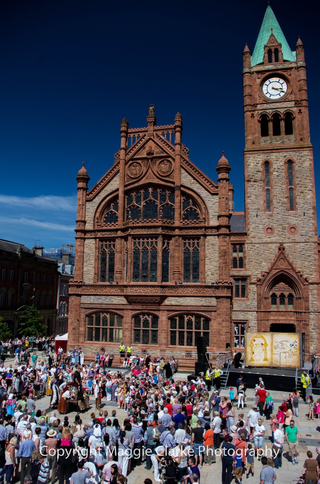
 The beautiful Guild Hall was bombed twice in 1972, and the guy they locked up for 15 years for doing / leading(?) the effort, is now a councillor, working inside.  They’ve rebuilt it, and it looks like it’s a few hundred years old (Neo gothic, it’s called).  Also, on this day there were celebrations of all sorts going on.  Had I known, I might have stayed in Derry overnight for the fireworks, but then again, the accommodation might have been subpar like in Belfast.  The celebration was of St. Columba going to Scotland to preach Christianity.  This was around 538 AD I think.

We ended the tour near the Peace Bridge, which was loaded with people, and I had no desire to go on.  But I watched from back of the Guild Hall, where I got a San Pelegrino orange, a sandwich, wrapped to go with paper and a string, and brownie, and watched as a couple of guys involved  in the celebrations, dressed in full length black robes and hoods, with hoops to hold the robes out in circular fashion, with long parchment in front, message probably in Gaelic, moving about the crowds on concealed Segways!  Oh, and also concealed must have been an ipod and battery amp since there was really deep creepy “music” coming out of it as well.

I spent another hour or so cruising the town on foot, going into small shops and the big shopping mall, and as my eyes tend to do, I laid eyes on this nice chocolate store:  Thorntons.  I wasn’t aware that this is a UK chain,and one of the best in the UK, but bought a couple of little bags of dark chocolate covered mint filling, and found it better than what I’ve had in the US.  They put in a certain little crunch that makes it even better! 

I had a couple of ways to get from Derry to Letterkenny, back in the Republic of Ireland, so I chose going up the river Foyle for a while.  But first, spent a little time in a lovely park along the river.  I’d been advised to wait on refilling the diesel tank until returning to Ireland, since it’s cheaper there.  This was true, though hard to calculate since Northern Ireland was in Pounds Sterling, and Ireland, Euros.  The diesel was cheaper than petrol in Ireland, that’s for sure (not always the case in Northern Ireland).

Though not a large town by many standards, Letterkenny is the largest in County Donegal.   Without realizing it, and not seeing enough signs (there were roundabouts lacking complete signage), I missed the turn to the N56 and cruised right through town.  That was ok, I’m typically good at realizing when I’m going wrong.  In town I’d passed a bar called the Cavern, and it even seemed to have the same lettering font as the one in Liverpool, so I thought I’d check it out.  Free parking across the street!

 But looking inside, it was largely empty, and not inviting, so I went next door to the Yellow Pepper.  Anything with that kind of name is inviting as far as I’m concerned.  The food was Great!  And yes, they had some vegetarian dishes.  Finally got on the N56 heading north out of town and recognized the turn into the Killerin House B&B as I’d done this maneuver on Street View of Map Google.


A word about driving in Ireland:  By the time I got to Letterkenny, I was getting better and more confident at roundabouts, speeding through the Gaelic to the English, always checking right first and remembering from mistakes.  Even the tiniest of roundabouts, those that you can drive over, change who has right of way.  It may seem as if you are on a main road going straight, but if there is a tiny roundabout at an intersection (which doesn’t even cause you to go around anything), the right of way is to the right.  Nearly smacked one coming in from the right as I tooled along a long straight road towards Ballymoney.  I also need to add a note to my steering wheel for the mornings.  Drive on the left.  It’s like I have to reset my habits on this every day.  Coming out of my B&B outside Letterkenny the next morning, there were no cars at all on a multi-lane road.  I reverted to old habits until I came face to face with one car, whose driver had the most incredulous look!  Ouch!

Jine 7 -- Belfast to Ballymoney

Got down the steep stairs from my tiny room (barely room to move) for breakfast today, which was eggs and beans, hot chockie, and OJ.  I’d gotten some directions from Kevin upon arrival, and he gave me some more specifics this morning.  I was double-checking his directions using my big format, spiral bound maps of the British Isle that I’d bought in Bristol at least 5 if not 7 years ago.  In planning part of this day’s route, I had used the street view of Map Google, but I always allowed for serendipity, new routes to go on a whim, or recovery from a missed turn.  On my way to the motorway, I passed by a long line of wall murals, which had to do with “the troubles”, all from the Catholic/Republican point of view.  I’d learned that my B&B was just off the Falls Road, which to those who know recent Northern Irish history, was a stronghold for the IRA.  It was easy to pull over and shoot some pictures.  As I did, from across the street, I realized this was a regular stop for tour buses.  Two were there with gawking, photo snapping tourists.


Without incident I got up the M2, M5, and to the Antrim Causeway coastal route (signed in brown, just like the previous day’s Mourne (mountains) coastal route had been.  Though I hadn’t been planning to, I saw a sign for the Carrickfergus castle in a roundabout, so stayed in it one more turn, got out and took pics of the castle.  The word Carrick (anglicized version of Carrig in Gaelic, meaning rock) is everywhere.  The coastal road started out normal, a two lane, and I took numerous opportunities, finding pullouts, and taking photos of the quaint villages and farms on the coastline.  Scotland was now in view.  At one point, yet another scenic route to Island Magee was signposted, I found myself a little off track, but it was pretty looking back at the mainland.  A little ways further, I stopped again to watch a giant ferry coming into Larne from Stranraer, Scotland.


 And again to admire the rocky coastline with green algae and orange lichen on the rocks.  It was a nice long drive right along the rugged coastline, with one lane tunnels, and where the road would sometimes rise up steeply along mountainsides

The geology kept changing, sometimes metamorphic, and sometimes bright white chalk and limestone.  There were quaint towns nestled at the foot of mountains, right along the coastline.   There were fields of blue and yellow flowers (buttercups) going down to the sea.


Thanks to my having ridden some of the route before on streetview of Map Google, I saw the critical turnoff for the Torr scenic road and took it.  The road, built onto the mountainside, became even prettier, but narrower and steeper.  Cars could barely pass.  I took a pic of a school bus (!) heading into the hedge as a car approached.

The road was not only narrow but also extreme in pitch, climbing and diving, back and forth.  There were lots of sheep and cows on the green hills, decorated by yellow-blooming gorse bushes with hedgerows and farmhouses.


The Mull of Kintyre in Scotland, where Paul McCartney and his clan lived and wrote the first few Wings albums, came into view.  I found out later that the underlying rock is Precambrian, metamorphic, very hard rock.  This makes sense (fits in with the topography being anything but gentle).  I passed some extremely strong bike riders, and got some pix of them coming up a steep hill.  They weren’t all that pleased with their progress, but even the car was straining to get up some of these hills; their performance put my cycling abilities  to shame.  Decided to switch from Raspberries to Herman’s Hermits on the CD player.


Getting back on the A2, I stopped in Ballycastle (no castle) for photos of the interesting geology and river in the distance, with a sculpture of flying geese in the foreground, and a soft ice cream.  I find it hard to take the time to sit down and have a proper meal when I am on the go like this.  One ponders (not for long), should I do the rope bridge or have dinner somewhere?  The answer is obvious.  I considered ordering the quiche, but it would have taken 10 minutes to heat (!) so I had the cone, admired the view, and was off again.

Just shy of Ballintoy, I got to the turnoff for Carrick a Rede rope bridge.  it's just a short steep ride down to the carpark.  There is an entry fee. This involved a kilometer hilly and very scenic walk.  The cliffs was just gorgeous on this day.  Here's a video I shot:

Approach to Carrick-a-Rede rope bridge


Getting to the bridge, the fellow manning it (the traffic cop who makes sure no more than 8 people would be on the bridge at one time and makes sure that no big lines in either direction would form) graciously helped me take pictures of myself.  Eventually, I set up the tripod and did some myself, using time delay, with various angles.

Though there had been a lot of build up, compared with some other similar rope bridge adventures, two in British Columbia, including the Capilano suspension bridge over a deep gorge, the Carrick a Rede was shorter, but the scenery was, by far, the best.  The shoreline and offshore island, connected by the bridge, are cliffs with lots of little nooks and crannies for birds to hang out.  And there were Lots.  They could be heard far away as we walked towards the bridge.  Got some shots of a trio of guillemots (razorbills.. protected in the US since 1918).

There were lots of gulls as well.  After crossing the bridge and climbing to the top of the offshore island, I captured a 360 video from the top.  It was not easy footing, with lots of rocks to navigate, steep trails, and I was a bit surprised to see a large Arab family, with the father hanging onto a tiny infant totally wrapped, not even strapped to his body.  He said the baby was 3 or 4 pounds!

By this time I was in shorts, the temperature having risen and still no clouds in the sky, no wind.  The Irish were knocked out by the string of really nice days, and I was quite happy it was that way, and not foggy or rainy.  It made the photography so spectacular!

Here is the 360 degree video I took from the top of the Carrick-a-Rede Island.

Carrick-a-Rede Island Video

Upon returning to the carpark, getting close to 6pm, I had a cloudy apple cider and a raisin scone at the cottage (that was dinner) and raced along the causeway route to The Giant’s Causeway.   This is a geological formation where intrusive molten rock (basalt) formed hexagonal columns upon cooling.  The perfection of the columns and extent of the formation make this a pretty rare occurrence on earth.
I got there after 6, too late to get into the visitor center with the geologic history about the rock formation, but the rocks, themselves, are always open.  In the US, they’d close it off, put an entry fee on it, put fences around it, allow ice cream trucks in, and pretty much trash it.  I appreciated how the areas around the rope bridge and these rocks, parking and tourist stuff is kept 1 km away, leaving people the beautiful unspoiled view.  To get to the rocks entailed another walk, not quite as hilly with the waves crashing on the shore, and colored cliffs above.  They have a bus to take people along the special road, but that stopped running before I got there.  No matter, it was a lovely walk.


The sun sets at 10 in this part of Ireland near solstice, so the sun was in the northwest.  I clambered onto some of the rocks, and did another video – about 270 degrees.  The basalt was not uniform in color.. some grey, some brown, some off-white, indicating variations in composition.


The Giant's CausewayThere is also an oral history involving giant Finn McCool, and Scotland, which I can’t quite remember.  That’s why it’s named Giant’s Causeway.  It was quite enjoyable hanging out on the rocks.  I had 1/5 of a chocolate bar and some water, watching the waves crash on the rugged shore.  I did attempt to get out onto the “point”, but it wasn’t clear how to get there.  I tried scaling rocks going around the edge, where water met the rocks, and then climbing to the top, at the recommendation of a young fellow who said it got flatter on top (no, it didn’t!).  Here's a video to give you a feel for the landscape.

The Giant's Causeway Video


But I couldn’t tarry a really long time, I probably spent an hour there, but had to come back to find my way to the Pinetrees B&B in Ballymoney.  It was maybe 15 miles away inland, and the phone I’d bought came in handy to call them and get directions… three times.  It seems in the British Isles, because the roads wind around so much, and signage often leaves out critical information, you can go off in a wrong direction, and then you’re done without map or other help.  But I was told that the people are particularly helpful in Ireland, and I’ve gotten lots of good quality help from other drivers and pedestrians.. much moreso than I remember getting in Scotland or England in similar situations (people didn’t even know local geography sometimes – like the street they were standing on…  ).  Tonight, a lady not only knew how to direct me to Ballymoney, a few miles away, but even knew the new police station that was a block from the Pinetrees B&B.   It was still light out around 9 when I pulled in, and the place was gorgeous.  Wood, decorative glass doors, lovely furnishings, and in the morning, the blooming trees out front and back, just breathtaking.  The hostess, I knew, was a gem from the day I booked telling me her place wasn’t that easy to get to from Giant’s Causeway without a car.  So after arriving, this night she gave directions for me to go on foot to one of the few places I could still get some dinner, as I was running on empty at this point.  Got a veg burger as I was decidedly low on fruits and veg at this point.


Monday, June 17, 2013

June 5-6; New York to Belfast

June 5-6 Friday-Saturday


Prelude
In past travelogues the first day is usually very dramatic, beginning with an all-nighter or close to it, nearly missing planes or trains, or something like it.  But this time, I wanted this trip to go really well; I’d never been to Ireland before, and not sure if I’d ever get back, so I’d spent more time preparing than for any I’ve done in a long time (maybe the “20 cities in 20 days trip I did around the Moodies’ Monaco show in summer 2004).  This trip was long in my mind, having originally planned it for September 2010.  But thanks to changing point schemes by Amtrak and Continental at the time (things like Amtrak now requiring you to expend $200 on train travel every year you wanted to exchange points for Continental, and inserting extra months here and there in making the switch, and Continental adding its own pesky rules and delays) , making it impossible to fly for free as I had in 2004, 2006 and 2008, as well as the escalating real price of air travel, and maybe some premonitions, I just cancelled my trip and sold 2 of the 4 Moodies tickets I’d bought.  Then my uncle died, Aunt Marge left alone for the first time in maybe 55 years, and my Mom broke her hip (funeral and hip break at the exact same time).  But I digress.

This time it made sense to do the final five concerts of the Moodies in the UK (Plymouth, Bournemouth, Brighton, London and Bristol), and fly directly from there to Chicago, where I’ll be speaking at my annual June conference (Air & Waste Management Association), where I’ve been chair or vice chair of a major Tech Council division for over 10 years, committee chair for 10 years before that.

Now that Continental and United merged, the comfy arrangement I’d had all these years with offloading excess Amtrak points to Continental no longer existed.  The new experience of gathering of points (to get free air travel) was a new challenge, so I explored using Points.com, to augment the too few points I had in my United account.  In a couple of weeks I managed to barter and trade with others, minimizing trade fees as much as I could, since I always have a plethora of Amtrak points.  So for about $400 total taxes and fees, I got Aer Lingus Boston to Dublin, 12 days later, Dublin to Gatwick, 7 days later Air Canada Heathrow to Chicago via Montreal.  I’m using free Amtrak for the NY to Boston and Chicago to NY legs.  (Btw, it’s the Amtrak Guest Rewards Mastercard that makes a lot of this possible.  I still highly recommend it, despite the lack of an outlet for excess points for air travel.)

Planning
Somewhere I’d seen an ad for “Explore Ireland”.  I initially thought it was something akin to an official government Irish Tourist Board or Chamber of Commerce.  I eventually found I was wrong about that (they were a travel agency), but in exchanging emails with them, I was able to get some more info on a few places to stay and things to see.  Since I’d done this before, I went back to the familiar.  For weeks I prepared a “Trip Bible” including a detailed itinerary for each day, contact info, reservations, maps, info on ferries, car rental, transfers, places of interest.  The first step was to determine where I wanted to go in Ireland, in what order, fitting driving distances that were doable with the sightseeing I wanted to do, adding some wiggle room, then to make room reservations.  Booking.com has been good in the past for finding good B&Bs and it was this time. 

I figured to rent a car for the whole time in Ireland, to allow flexibility in where to go and how long to stay there.  That would give me the most control over photo opportunities.  The train system in Ireland is not that extensive, as it is in England and I wouldn’t have been able to cover anywhere near as much ground without a car.  I had, in previous trips, driven a car in Scotland, England, and Wales, so I knew the rudiments of UK driving (on the left became second nature.. most of the time.. learning the cooperative driving and weaving around parked cars that occupy most of a travel lane, driving narrow roads, even one lane or single tracks as they call them).  I even learned how to read and navigate with the rather lengthy and sometimes confusing signs at each of the ubiquitous roundabouts.  I put together maps for each day’s drive, a cue sheet using map.google for each day’s drive, reservation pages and ferries/other sightseeing info, and an itinerary.  I made a copy of this and brought it with.  I had already purchased a very large format spiral bound map set of England, Scotland, Wales and Ireland, so brought that with a couple of books that I’d bought in preparation for the trip (Backroads of Ireland, Lonely Planet).  So I didn’t think twice about renting a car.  I initially put in for the smallest car I could get with Avis, figuring I’d make a few more along the way and choose the best before the trip began.  I did make sure that it would have an automatic transmission.  Those cost a lot more, but if you need it, You Need It!  

I’d heard a lot about the Giant’s Causeway and had seen pictures, and being a PhD in earth (and environmental) science, this was the first scenic wonder that I wanted to make sure to see.  Nearby (15 minutes away) was the Carrick-a-Rede rope bridge, connecting the mainland with an offshore island; that was also a “must do”.  So this meant a swing through the northern coasts (the Antrim coast), which I thought would be quite scenic.  I located some of the other most scenic spots, strung them together, knowing that I’d be coming back to Dublin to pick up Lorraine and drive with her for the rest of the Ireland tour (before we started our Moody Blues southern England tour, that is).  Though I printed out maps and routes, I would leave some of the precise routing to the day before and each day on the road, based on advice from locals and B&B hosts.  The hardest part would be figuring out, on the fly, how long to spend in each scenic spot, historical site or town, so that I might arrive at the B&B at a reasonable time and get a reasonable amount of food and sleep.  I realized in the planning of this trip, I think it was on TripAdvisor.com, someone had divided the universe of travelers into two camps: 1. Those who pack in as much as they possibly can, and 2. Those who travel to a nice place and plop themselves down for the duration.  I’m obviously in the former camp.

Photography was one of the major interests for this trip – both landscape and concert photography.  This required that I make room on my laptop and have enough SD cards.  Though I already was bringing a 32, a 16, a 4 and two 2 gb cards, I’ve recently gotten caught short, and wasn’t sure how many I would need, so I got an 8 at Kmart in Penn Station anyway.

A final note on planning, communications has become a very important part of travelling in the 21st Century.  While in the pre-internet, pre-cellphone era, one would often not be in that close or frequent contact, now one is.  In my case, I felt very nervous about my 95-year old Mom and 97-year old Aunt Marge back in New York.  So I found and bought an international phone (Mobal).  They had a few different models, all of which would charge you per minute, in addition to the cost of the phone, along with a free set of electrical converters.  Since the cheapest phone “only” worked in 170 countries, But Not Canada (!), I bought the next one up for an extra $50 which includes Canada and most cruise ships.  Hmmm.. might come in handy. 

The Start
The day of leaving for the trip, was fairly uneventful.  Though I hadn’t had time to put together my presentation for the panel I’m speaking at on zero waste economics / return on investment for the Chicago conference which is to follow immediately after the Bristol show, I did put a powerpoint together on the train to Boston, very pleased that I could do that.  Wifi on Amtrak is a Godsend. 

Aer Lingus had said to arrive at Boston Logan airport 3.5 hours early.  I found this highly suspect, never having been told to arrive anywhere more than 2 hours ahead.  I managed to get there 3 hours early, using, for the first time, the MBTA’s Silver Line (newest “subway” line to get to the airport from Amtrak’s South Station).  This actually passes by a venue that we’ve seen the Moodies perform at a few times, and part of the route is electrified bus running in a dedicated tunnel, and part is regular bus.  I realized my trip to Ireland was about as intermodal as one could get..  subway to Amtrak, to subway/bus, to plane, to car.  I even had a bike tour of Belfast lined up for my first day in Ireland.  The only thing I didn’t go on was a ferry.  But I digress. 

Back at Logan, there was no one in line for check in (!), so that went fast.  The line for security was short too, so I found a cafĂ© and spent time on the phone and online.  Spoke to my aunt Patty (father’s sister, who I’ve met only a couple of times) who had been to County Tyrone looking up the ancestors who left for Quebec in 1826 (but not finding).   The flight was gentle enough, but I only got about an hour’s sleep, just sound of Greenland.  I could not sleep.  The lady next to me was reading all night, light on, and windowshade open (morning light coming in after 5am).  There was a crying kid now and then as well.  Of course they feed you 1.5 hours after takeoff and ¾ hour before landing during a 4.75 hour flight.  This lack of sleep made for an Awful start to the trip.

Ireland!
Arrived early at Dublin airport, but there were major lines for passport check.  After picking up my bag, it was confusing… where do I pick up my Alamo car?  All the car hire agencies were listed except that one; I dragged my stuff halfway to the other terminal when something made me go back.  Turned out that Europcar handles both Alamo and National.  That wasn’t clear on the reservation I’d made. 

Then if this aggravation wasn’t enough, I was baited and switched at the counter.  Immediately the lady was trying to switch me from the smallest car to a larger one to another and back again, bigger, smaller, bigger, smaller, diesel, petrol, diesel, petrol, meanwhile other parties were coming and going, being processed efficiently by her partner at the counter (gee I wish I’d gotten her!)  My host the first night at the Springfield B&B in Belfast said they probably didn’t even have the small car I had booked.  I ended up paying another 55 euros for a larger car that I should have declined.  

Seems that every time I book a car in England, now Ireland, I learn some things.  Last time it was to bring a copy of the Mastercard-generated statement, dated just before leaving for the trip, that I own a World Mastercard which covers my collision insurance.  In the British Isles they seem to hate this arrangement as they want to sell you collision insurance as well as some extra insurance that we don’t even have in the US, not to mention liability insurance.  I remembered well the agony of having spent hours at the start of a previous rental trying to get the statement from Mastercard.  This time, I learned about the flim flam bait and switch.  All this got me a bit more nervous and tired than I already was, which was considerable.   I also realized later, that they never came out to go around the car with me and note previous damage.  Another lesson learned. 

Out on the road at first I thought I was acclimatizing to driving on the right side of the car, left side of the road thing, riding up the M1.  A motorway is the best place to start, since the road is not narrow and you have multi-lane expressway driving.  This time there was a new thing to get used to:  Gaelic on the road signs.  It’s the first language on every sign.  The English is below in Caps, making each sign harder to read.  But it didn’t take too long to get good at reading the signs.  I got off the M1/M2 in Newry.. had what I guess is the obligatory first missing of a sign or seeing it too late to turn, so I spent a bit of time touring that town.. nice castle!  I had gone off the main road to Belfast so that I could do some driving along the Mourne coast road (named after the Mourne mountains that go down to the coast).  It was very neat that they had brown signs to indicate destinations or roads of scenic interest and made it easy to follow all the turns and roundabout directions.  By this time I was in Northern Ireland (the UK).  There is no border crossing.  I didn’t even remember seeing a sign.  There was a light mist, but otherwise sunny and amazingly lovely.  I knew before leaving that the forecast was going to be unbelievably great .. no rain for a There were green hills, lots of sheep and cows, and gorse, this big shrub with yellow flowers that I'd seen all over Scotland.


I had my first meal in Ireland, a full breakfast at about noon.

So I drove into Belfast… not easy to find where I needed to be, but I’ve been told, and it seems to be true, that the Irish are very helpful.  A guy in a car next to me had his window open sitting at a light, so I got perfect directions to where I needed to go (through 5 lights, turn left).  He even let me cut in front of him at the light, since I was in the wrong lane, and waved, when I made the left turn.  I’d made a reservation to take a Belfast City bike tour at 2pm.  I was late, but I’d phoned when I was grabbing a breakfast) somewhere along the coast, and turns out I was the only one on the tour, so it was ok if I was going to be late.

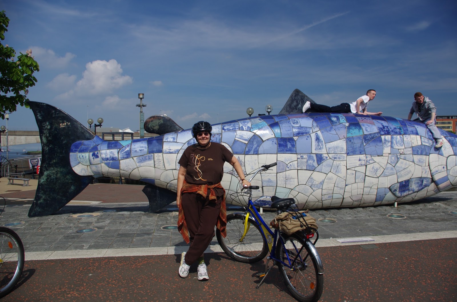
The guide was good, we were on cruiser bikes with fat tires, for three hours going all over town and even into nearby suburbs to tour the botanical garden, free to the public, and loads of people sunning themselves on the great lawn (it being such great weather).  It reminded me of Sheep Meadow in Central Park, on a smaller scale.  My host treated me to an ice cream.


 We went to the City hall, the Titanic exhibit, along the river, and some historic pubs and locations. One had some murals on a wall. See if you can recognize anyone:

He gave me quite a bit of history too, including “the troubles”.  This still dominates thought in Belfast, and I learned I was a pioneer in being a tourist in Belfast.

After the bike tour, between 6 and 7, back in the car, I found my way along the Falls Road to my digs in the heavily Catholic area.  There was IRA graffiti on the walls, anti-Thatcher stuff, political murals, etc.  Seems they still have a wall between this area and the Protestant area and the police shut the gate every night as a crime prevention measure.  Used to be one side would go to the other side at night, murder someone and return back to their home area.  Not anymore.

The Springfield B&B was not nice.  I should have stayed outside of town or in a nicer hotel.   The owner, Kevin, was nice enough, recommending some places to get food (I was absolutely falling over at this point).  I go to this Chinese takeaway, not wanting to wait for a pub meal (Mom always said Chinese food works all over the world).  In this case, I asked for chicken and veg, and got greasy chicken and noodles, and before I arrived back at the B&B I realized I had a migraine.  I knew I had to eat, but could only take a little of it.  Woke up after 5 hours, still with a headache, but did eventually manage to get more sleep.